Mercury is a particularly toxic metallic element, and its spatial distribution in the environment is critical to better understanding it.
In a recent study published in Proceedings of the Natural Academy of Sciences, a network The international network of researchers, led by the Coastal Laboratory, environment and society (LIENSs – UMR 7266). Norwegian Polar InstituteSeabirds have been used as bioindicators to map the distribution of mercury over a very large scale in the North Atlantic Ocean.

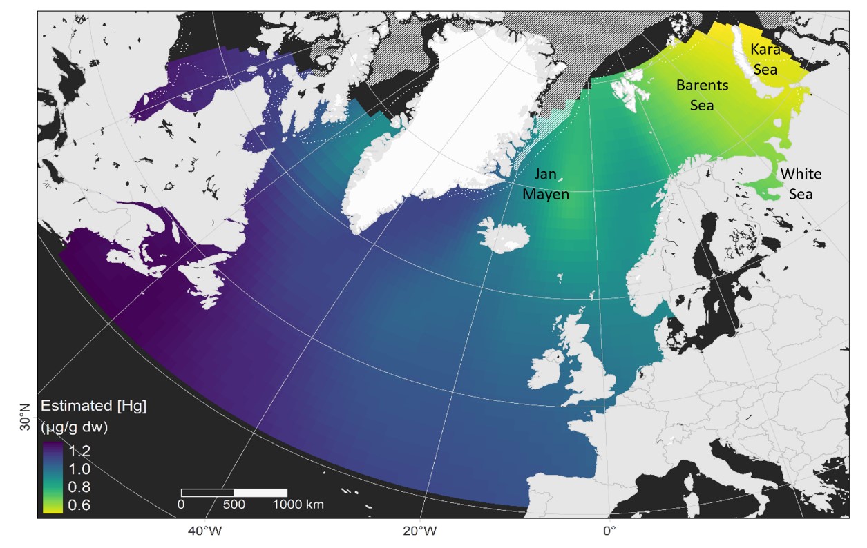
Mercury concentrations (in log) in the North Atlantic Ocean were predicted using Arctic seabirds as bioindicators.
Source: https://doi.org/10.1073/pnas.2315513121
Although mercury is a natural element, its concentrations have increased significantly in the environment over the past two centuries following increased human activities and burning of fossil fuels. At high concentrations, it becomes toxic to living species, including humans, with known effects on behavior, Reproductionor even Physiology Organisms. Therefore, mercury concentrations in the environment are closely monitored by international bodies in order to regulate its emissions. Therefore, in order to protect natural environments and animal populations, it is necessary to better understand the spatial distribution of this pollutant. However, this knowledge is often difficult to acquire among organisms in the marine environment, due to technical limitations or the financial cost involved.
In this study, seabirds were used as bioindicators to monitor and map mercury concentrations in the marine environment. Thanks to international cooperation between networks Arctox (Monitoring of mercury in seabirds on a generally Arctic scale) and Seat track (Monitoring the spatial distribution of seabirds at sea), A sum 837 birds of seven species and 27 different colonies were monitored over a period of four years. The concentration of mercury in the feathers of each was measured Individually Their spatial distribution is determined using systems Geolocation.

Atlantic puffin (Fratercula arctica), equipped with a tracking system (GLS)
© Sebastien Decamps
The results obtained highlight the distribution of mercury over a very large spatial scale across the North Atlantic Ocean. They show a longitudinal gradient of measured concentrations, less in the European part of the North Atlantic and the Arctic. More specifically, mercury hotspots have been identified in southern Greenland as well as eastern Canada, where concentrations are up to three times what they were in Barents sea (Norway) or in Kara Sea (Russia).
This spatial distribution indicates the influence of ocean currents and the melting of the Greenland ice sheet on the distribution of mercury in food chains in the North Atlantic. Above all, it provides essential knowledge to support international bodies that specifically aim to regulate mercury pollution on a global scale. This study continues today as part of the ARCTOX network and long-term monitoring by the CNRS to evaluate how the distribution of mercury and identified pollution hotspots have changed over the past 10 years and will continue to evolve in the future.
reference:
Seabirds reveal the distribution of mercury across the North Atlantic.
Proceedings of the National Academy of Sciences of the United States of Americapublished on May 13, 2024.

“Hardcore beer fanatic. Falls down a lot. Professional coffee fan. Music ninja.”


More Stories
SALES / PHOTO SALES – Nikon D850 “5 Star” Bare Body Photo Body at €2,539.00
Discovering a new turning point under the Antarctic ice sheet! What are the consequences?
Record number for an insect!